About GPS Fields Area Measure Map
Mark, measure & share land areas easily. Perfect for farming & surveying. Download now! Do you own the field and want to place marker, measure the distance, perimeter, or area of it? GPS Fields Area Measure is a free app...
Mark, measure & share land areas easily. Perfect for farming & surveying. Download now!
Do you own the field and want to place marker, measure the distance, perimeter, or area of it?
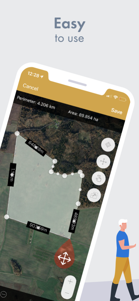
GPS Fields Area Measure is a free app that allows you to evaluate your fields as you need: measure the distance, perimeter, or area and share it with your colleagues straight away!
"Very accurate and precise. I use this to calculate how much spray, fertilizer, chicken litter, paddock size for planting various grass seed, etc." - says our user in an app review.
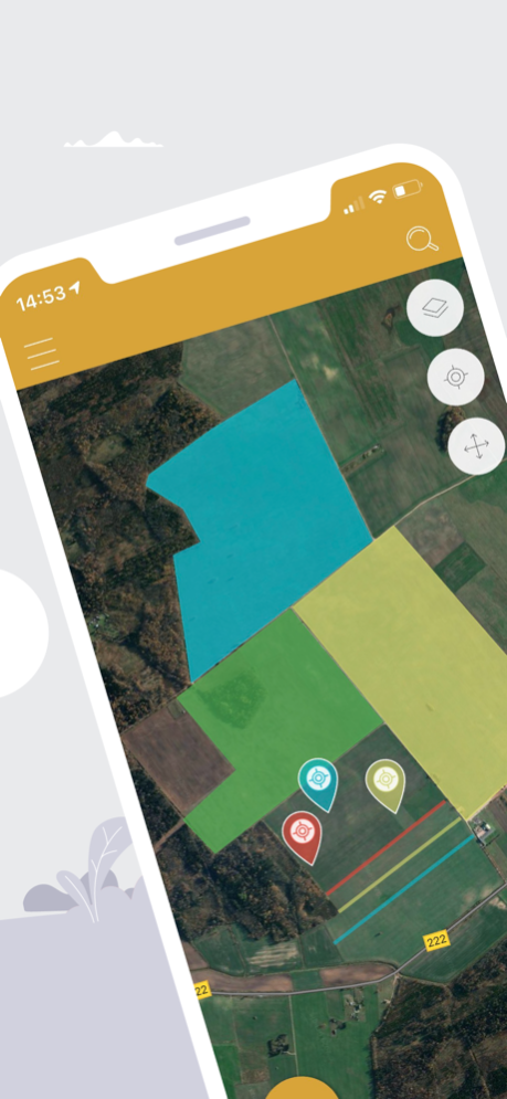
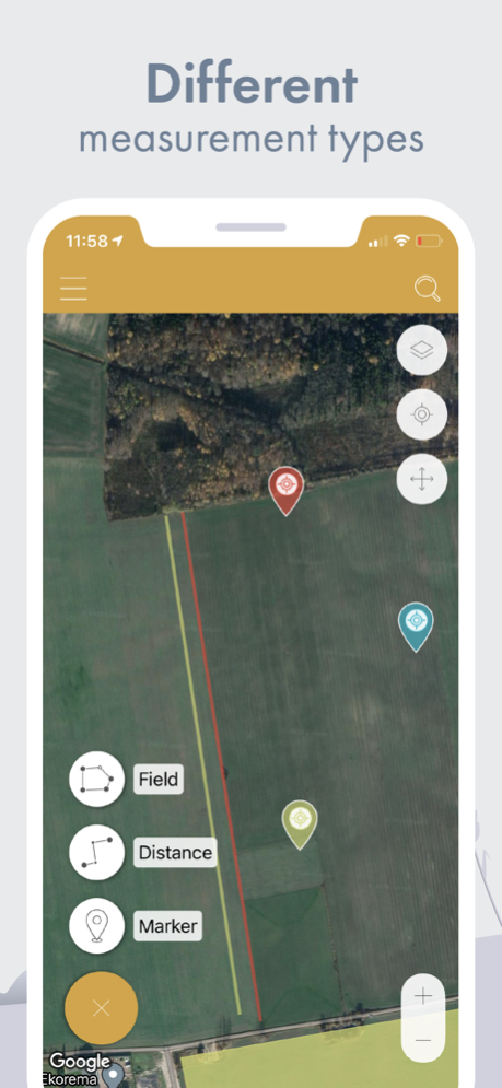
Get the distance between the objects, determine the property lines, and find out the exact area of the field. GPS Fields Area Measure app allows assessing the area in a multitude of Imperial or Metric system units including square feet, acres, or kilometers.
WHY IS IT USEFUL TO USE GPS FIELDS AREA MEASURE APP?
• USE IT ONLINE&OFFLINE: use the app whenever you need to, mark your points-of-interest, check the distance, perimeter, or area of the field when you need the most.
• STAY IN TOUCH WITH YOUR COLLEAGUES: share updates and measurements with your friends or colleagues in .kml .kmz or Esri Shapefiles. Export and import shared files, stay connected to communities important to you.
• EASIER MONITORING: divide your measurements into different groups. Name it and write a description for it, add pictures – ensure easier recognition!
• CONVENIENT MARKING: choose how you want to mark your points, do it manually, or by using a GPS mode. More precise marking just in a few button clicks.
• AVOID MISTAKES: by having an accurate map and marked points be sure about avoiding stones, mark fences more or boundaries of paddocks more clear.
• SAVE MONEY: convenient tool straight in your mobile app, avoid buying the field measurement equipment, and save thousands.
HOW TO FULLY OPERATE THE APP?
Use the app to measure the fields and the distance of the property, to determine the property lines. Explore and mark the most important places in your field, customize the information, and be sure that you have easy to use tool for your measurements.
SUBSCRIPTION
The most relevant features straight in your mobile app - synchronize all of your data to the cloud and make sure you will not lose all of your saved measurements; add pictures and descriptions to your fields; easily navigation between the measurements and location and many other features you have to try.
Continued use of GPS running in the background can dramatically decrease battery life.
GPS Field Area Measure comes with Auto-renewing In-App Purchases.
• 1-month Premium subscription.
• 6 months Premium subscription.
• 12 months Premium subscription.
• Payment will be charged to iTunes Account at confirmation of purchase.
• Subscription automatically renews unless auto-renew is turned off at least 24-hours before the end of the current period.
• Account will be charged for renewal within 24-hours prior to the end of the current period, and identify the cost of the renewal.
• Subscriptions may be managed by the user and auto-renewal may be turned off by going to the user's Account Settings after purchase
• Links to Your Privacy Policy
• Any unused portion of a free trial period, if offered, will be forfeited when the user purchases a subscription to that publication, where applicable.
With premium bought thru In-App Purchase you will unlock these features:
• Share multiple measurements
• Ads will be removed
• Change group colors
• Cloud synchronisation
• Photo add to measurements
The most important app in your work, especially if you are a farmer or an agronomist, if you need to make land surveying or to create a geodesic line.
Measuring your fields was never so easy!
• Privacy policy: https://privacy.farmis.com/
• Terms of Use: https://privacy.farmis.com/
Apr 22, 2024
Version 2.16.3
- Bug fixes
Previous Versions
Here you can find the changelog of GPS Fields Area Measure Map since it was posted on our website on 2021-12-23 06:01:56.
The latest version is 2.16.3 and it was updated on 2024-04-27 11:18:23. See below the changes in each version.
GPS Fields Area Measure Map version 2.16.3
Updated At: 2024-04-22
Changes: Apr 22, 2024
Version 2.16.3
- Bug fixes
GPS Fields Area Measure Map version 2.16.2
Updated At: 2024-04-19
Changes: Apr 19, 2024
Version 2.16.2
- Bug fixes
GPS Fields Area Measure Map version 2.15.1
Updated At: 2024-02-29
Changes: Feb 29, 2024
Version 2.15.1
- Bug fixes
GPS Fields Area Measure Map version 2.15.0
Updated At: 2024-02-13
Changes: Feb 13, 2024
Version 2.15.0
- Bug fixes
GPS Fields Area Measure Map version 2.14.1
Updated At: 2024-02-01
Changes: Feb 1, 2024
Version 2.14.1
- Bug fixes
GPS Fields Area Measure Map version 2.13.0
Updated At: 2024-01-24
Changes: Jan 24, 2024
Version 2.13.0
- Synchronization improvement
GPS Fields Area Measure Map version 2.12.2
Updated At: 2024-01-03
Changes: Jan 3, 2024
Version 2.12.2
- POI bug fixes
GPS Fields Area Measure Map version 2.12.1
Updated At: 2023-12-08
Changes: Dec 8, 2023
Version 2.12.1
- GPS Bug fixes
GPS Fields Area Measure Map version 2.11.1
Updated At: 2023-11-22
Changes: Nov 22, 2023
Version 2.11.1
- Bug fixes
GPS Fields Area Measure Map version 2.11.0
Updated At: 2023-11-15
Changes: Nov 15, 2023
Version 2.11.0
- A new map with better performance has been implemented